
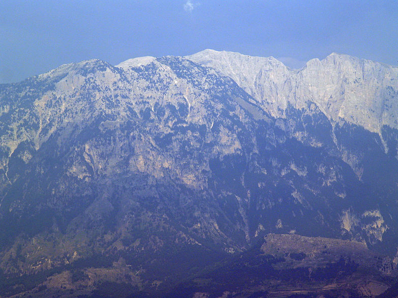
Mount
Tomorr is a
large mountain in southern Albania. Its highest peak, called Çuka e Partizanit, reaches
a height of 2,416 m (7,927 ft). It is located east of the towns of Berat and Poliçan and the
river Osum not far from the Canyon of Osum river .
In antiquity the region of Tomorr was inhabited by the Dexari, a tribe of Epirus that belonged to
the Chaonian group of the northwestern Greeks.


Albanian folklore tells how Tomorr came to be. The people believed
that Tomorr was a giant that wanted to fight another giant named Shpiragfor a young woman. The two giants killed each other and when
hearing this the young woman cried and drowned in her own tears thus creating
the river of Osum.
Tomorr is of great spiritual importance to the local people. On
the summit of the mountain a Bektashi shrine to the brother of Imam Husain,Abbas ibn Ali can be found. Each
August thousands of faithful make pilgrimage to this shrine.
Tomorr also offers many sports facilities such as skiing. For its
importance and beauty the Albanian Government declared Tomorr a National Park. Tomorr Mountain National Park covers an area of 4,000 hectares. Many
endangered species are free to roam and live there.


Hello
ReplyDeleteI am now in Berat, and i wont hike this mountain, someone know where is the best spot to start, witch is the best route? i cant find nothing, in internet
This comment has been removed by the author.
DeleteHi, there are some old maps: http://download.maps.vlasenko.net/smtm50/k-34-113-3.jpg
Deletehttp://download.maps.vlasenko.net/smtm50/k-34-125-1.jpg
If you want to climb Tomorr (the lower one with the shrine), there is a road the leaves (to the left) the road connecting Berat and Çorovodë just after Poliçan. It goes all the way up to the shrine. There is a pathway (probably more interesting) that clims to the mountain from the east, but I do not know where it begans. The road goes from the south. As for the higher one, Çuka e Partizanit, there is a road sort of connecting Berat and Gramsh (look at Google Maps and this link: http://www.palmtreeproduction.com/Hikes%20and%20Climbs/Albania%20Climbs/Tomorri/Tomorri.html ) - you can set off from there.
The ridge can be crossed from one summit to the other if you are tough, but I am not sure how tough you need to be. There is no path and lots of rocks (that usually can be walked around). We had to stop south of Çuka e Partizanit due to weather, so there may be some problems there. This would be for at least two days, rather three, the terrains is difficult to navigate!
I went through a very painful breakup with my boyfriend. We stopped talking, and he even blocked me on all social media. I was heartbroken and didn’t know what to do, so I started searching online for help. That’s when I came across several testimonies about Dr. Dawn and how he had helped people reunite broken relationships and marriages, as well as helped women conceive through his guidance.
ReplyDeleteAt first, I was unsure, but I decided to reach out to him. When we spoke, he told me things about myself and my relationship that were surprisingly accurate. He then guided me on what I should do.
To my surprise, within 48 hours, my boyfriend—who had completely cut me off—started calling me and sending me many messages, apologizing and asking for forgiveness. I forgave him, and we got back together.
Not only that, but with his support and guidance, we are now blessed with two beautiful children.
I am truly grateful for everything, and I strongly recommend Dr. Dawn to anyone going through relationship, marriage, or fertility challenges.
His WhatsApp : +2347041196471
dawnacuna314@gmail.com